|
10/17/2018 Fixing Base Lines: An Interplay Between Environment And The International RelationsRead NowThis blogpost is writen by Anubhav Bijalwan and Deeksha Gupta, 3rd Year B.A.LLB (Hons) students at Dr. Ram ManoharLohiya National Law University, Lucknow. INTRODUCTION In the last two decades we have witnessed extreme seasons globally. Such severe weather conditions are a direct manifestation of global warming and climate change. Arguably the most powerful and adverse impact of climate change is the continuous rise in sea level. According to NASA average rate of change of sea level is 3.2 mm per year. It can be better understood with help of the graph below.[1] 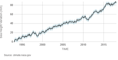 Rise in sea level leads to an inward movement of sea water which in turn alters the Low Water Mark Line (hereinafter LWML) of the state. According to UNCLOS, LWML of a state is its base line[1], from which all the maritime zones of the state are measured. These maritime zones include territorial sea, contiguous zone and exclusive economic zone, as illustrated in the diagram below. Any shift in LWML also changes the base line. Therefore, the question arises, whether the boundaries of maritime zones should also be changed to match this altered (new) base line? Article 76(9) of UNCLOS states that the "coastal state shall deposit with the Secretary-General of the UN charts and relevant information, including geodetic data, permanently describing the outer limits of its continental shelf", thereby, merely indicating and not mandating that the maritime boundary once decided ought to be permanent. This lack of finality has many a times lead to a dispute between the nations. 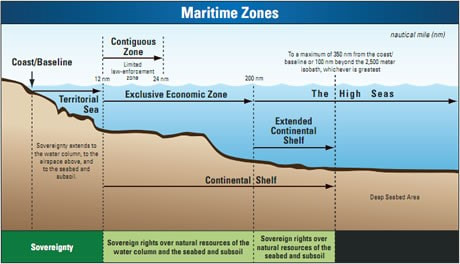 This article analyzes the interplay between sea level rise and International relations in the light of disputes that have arisen before the adjudicatory bodies. UNCLOS in its current form fails to deal with the disputes of such nature leading to incoherent and myopic decisions. Thus revealing the grey area in the international law which requires immediate deliberation. Possible suggestions have been discussed to bring uniformity in dispute resolution by fixing the base lines.
OVERVIEW OF THE DISPUTES In disputes between the states as to the delimitation of maritime zones, the courts tend to give a temporary solution to the problem. This can be better understood with the help of two recent cases, one between India and Bangladesh, another concerns Nicaragua and Honduras. Initiating the proceedings against India in 2009, Bangladesh requested for the delimitation after taking into consideration instability of the coast, its concave shape and its dependency on the fisheries.[1]The tribunal opined that the present situation is important in deciding the matter and anticipatory changes cannot be considered,[2] thus, leaving room for disputes due to rise in sea level. In the second case, in the process of delimiting the maritime boundary between Nicaragua and Honduras, the Court encountered two issues caused by the unstable geomorphology at the mouth of River Coco: (i)finding the current location of the land boundary terminus; (ii)identifying base points for the construction of a provisional equidistance line. The unstable nature of river mouth has caused uncertainty to such an extent that the court decided not to adjudicate upon the issue of sovereignty over the island.[3] LACUNAE IN EXISITNG LEGAL REGIME In 1980’s when UNCLOS was enacted, no one was aware of most significant threat of the coming decade i.e. climate change. Although it was being discussed at various platforms, its adverse effects were not as evident as they are today. While UNCLOS embraces a degree of change, changes in tides for example, it certainly does not envisage changes on this scale.[4] Therefore, UNCLOS is devoid of provisions which would help in dealing with the various problems posed by the climate change including changing maritime boundaries due to rising sea level. In UNCLOS, all the maritime zones are measured from the baseline. However, it is silent as to the condition when these baseline changes due to rise in sea level. According to the convention, the state has to deposit the coordinates of its baseline with the United Nations, once this instrument has been deposited, UNCLOS does not provide any answers as to the course to be taken in the case of significant change in the base line due to rising sea level. Therefore, this acts as a major impediment in the resolution of disputes between the state that are caused by these changes in the practical position of the baseline and thus maritime zones. Simply put, UNCLOS does not expressly provide that boundaries move with baselines. APPROACHES POSSIBLE AND THE RIGHT STANCE THAT OUGHT TO BE TAKEN Let us examine two possible approaches to this problem - Ambulatory baselines - In interpreting article 5 of UNCLOS, the International Law Association recommended that normal baselines could be dynamic thus, envisaging an ambulatory baseline system that reflects the actual geographical conditions.[5] Scholars have suggested renegotiation of maritime agreements to correspond with geographic realities as the maritime boundaries must move with the altering baselines. However, this approach perpetrates uncertainty in legal relations as it leads to states having variable coastlines to undergo the onerous process of changing their maritime limits and leaves fodder for disputes in general and ambiguity in exercise of right to hot pursuit and right to innocent passage in particular. Fixing the Base line- The silence of UNCLOS as to the permissibility of ambulatory baseline can be taken to show the intention of nations to keep them stable. Fixation of baselines will help in avoiding many problems including disputes between the states as to the boundaries of maritime zones. Disputes once settled, will be settled for always. Also, it will help in avoiding the costs of artificially maintaining the coastline and to regularly revise them. CONCLUSION Base lines should be fixed in order to realize the primary purpose of UNCLOS to maintain peace and bring stability. Moreover, baseline is more a legal concept than a geographical concept thus can be different from practical geographical condition.[6]Therefore, there is a pressing need to amend the UNCLOS to incorporate that the base line of nation will not change with the change in geophysical condition unless the state itself renegotiates the same. *This blogpost is writen by Anubhav Bijalwan and Deeksha Gupta, 3rd Year B.A.LLB (Hons) students at Dr. Ram Manohar Lohiya National Law University, Lucknow. [1]Global Climate Change, NASA, https://climate.nasa.gov/vital-signs/sea-level/. [2]United Nations Convention on Law of Sea, 1982, art. 5. [3]Bay of Bengal Maritime Boundary Arbitration between Bangladesh and India, ICGJ 479 (PCA 2014) 62. [4]Bay of Bengal Maritime Boundary Arbitration between Bangladesh and India, ICGJ 479 (PCA 2014) 63. [5]Territorial and Maritime Dispute between Nicaragua and Honduras in the Caribbean Sea, ICGJ 23 (ICJ 2007) 704. [6]Catherine Redgwell, UNCLOS and Climate Change, 106 Am. Soc'y Int'l L. Proc. 406, 409 (2012). [7]Sarra Sefrioui, Adapting to Sea level Rise – A law of the sea perspective, The Future of the Law of Sea 29(Gemma Andreone, Springer Open, 2017). [8]Sarra Sefrioui, Adapting to Sea level Rise – A law of the sea perspective, The Future of the Law of Sea 34(Gemma Andreone, Springer Open, 2017).
0 Comments
Leave a Reply. |
Archives
June 2023
Categories |
 RSS Feed
